Mount Kilimanjaro, Africa’s highest peak, is a beacon for adventurers worldwide. While the physical ascent is a formidable challenge, understanding the mountain’s geography through a well-detailed map is the first crucial step in planning a successful and safe climb. A good Kilimanjaro map isn’t just a navigational tool; it’s a storyteller, revealing the mountain’s grandeur, its diverse ecosystems, and the pathways that lead to its majestic summit.
A Mount Kilimanjaro map provides a visual guide to the routes, camps, elevation changes, and geographical features of the mountain, crucial for planning a climb and understanding the ascent. These maps typically detail multiple climbing routes, such as Marangu, Machame, Lemosho, Rongai, and Northern Circuit, highlighting their starting points, overnight camps, and exit gates (often Mweka Gate). Beyond routes, Kilimanjaro maps also illustrate the distinct ecological zones, from the cultivation zone at the base to the arctic summit, and can help understand the mountain’s volcanic geology and its location in Tanzania near the Kenyan border.
Mount Kilimanjaro Map: Navigating Your Way to the Summit
A Mount Kilimanjaro map serves as your essential guide, a crucial companion whether you’re planning your expedition from afar or hiking on its slopes. It’s the blueprint that allows you to visualize the mountain’s immense scale, its various approaches, and the intricate network of trails. For aspiring hikers, studying the map meticulously helps in choosing the right route, understanding the daily distances, elevation gains, and the strategic placement of campsites. It’s the silent partner that helps you navigate your way to the summit, providing critical information for acclimatization, logistical planning, and overall safety.
The Importance of the Kilimanjaro Map
The importance of the Kilimanjaro map cannot be overstated. Beyond simple navigation, it’s vital for. A map of Mount Kilimanjaro is crucial for planning a successful and safe climb, providing vital information on routes, acclimatization points, terrain, and the mountain’s overall geography. Including its ecological zones and cultural significance. It helps in selecting the most suitable route based on fitness and experience, aids in gear preparation, and offers a comprehensive overview of camps and resting points.
Route Selection. Each route offers different challenges, scenery, and acclimatization profiles. A map allows you to compare them visually. Kilimanjaro has seven different ascent routes, each with its advantages and disadvantages regarding difficulty, time, and summit success rates. A map helps in comparing these routes and choosing the one that best fits your physical fitness, climbing experience, and time constraints.
Altitude Awareness. Maps clearly show elevation contours, helping hikers understand the daily altitude gain and potential for altitude sickness. The map visually displays the elevation changes along different routes, highlighting critical acclimatization points crucial for adjusting to high altitudes and reducing the risk of altitude sickness.
Logistical Planning. Identifying water sources, ranger posts, and emergency evacuation points. By showing the various terrains encountered on each route (e.g., rainforest, heath, alpine desert), a map assists in preparing appropriate gear for diverse conditions.
Safety. In conjunction with an experienced guide, a map aids in maintaining situational awareness and helps in case of disorientation (though independent hiking is prohibited). While guided climbs are common, understanding the map allows for better comprehension of your progress and helps in navigating effectively, especially on less-traveled routes, contributing to a safer ascent.
Understanding Ecosystems. The map often delineates the five climatic zones, showcasing the incredible biodiversity you’ll traverse. Beyond navigation, maps can highlight the distinct ecological zones of the mountain and even indicate cultural sites and villages near its base, enriching the overall experience.
Understanding Geographical Context. A map provides a clear picture of Kilimanjaro’s location in northern Tanzania, its proximity to the equator, and its status as a UNESCO World Heritage Site within Kilimanjaro National Park.
Accessing a Reliable Mount Kilimanjaro Map
To access a reliable map of Mount Kilimanjaro, you can use interactive maps provided by tourism and climbing guide websites. Or explore detailed views on platforms like Google Maps and ArcGIS Online. Offer various levels of detail and information on routes, elevation, and geographical features. To ensure accuracy and safety, accessing a reliable Mount Kilimanjaro map is paramount.
Reputable Tour Operators. The best tour operators provide detailed, up-to-date maps as part of their pre-trip information. These are often custom-made with their specific campsites and emergency points marked.
National Park Authority. Kilimanjaro National Park (KINAPA) often publishes official maps.
Specialized Cartographic Companies. Companies like “Harald Flatters” or “National Geographic” produce high-quality topographic maps of the region.
Online Resources. Many well known hiking websites offer downloadable maps or interactive versions. But always cross-reference with your tour operator. It’s advisable to have both a digital version (on a phone/GPS device) and a printed, waterproof map as a backup.
Kilimanjaro Map Key Elements
A Kilimanjaro map key typically highlights trail elements. Campsites and huts, elevation changes and climatic zones, and geographic features like the summit, glaciers, and surrounding park boundaries. A comprehensive Kilimanjaro map is rich with information, and understanding its key elements is crucial:
Routes. Marked lines represent the established paths to the summit. Each route will have its distinctive path, length, and elevation profile. This includes starting points (gates), the paths of different routes (e.g., Machame, Lemosho, Rongai), and where they merge or converge.
Landmarks. Prominent geographical features such as volcanic craters (Kibo, Mawenzi, Shira), peaks (Uhuru Peak, Stella Point, Gilman’s Point), valleys, ridges, and significant rock formations (e.g., Lava Tower, Barranco Wall).
Campsites. Designate overnight stops along each route. Usually with facilities like toilets and water access. Their names and altitudes are critical for daily planning. Locations of overnight stops, such as Mandara Hut, Shira Camps. Barranco Camp, and Barafu Camp, are crucial for planning the climb.
Altitude. Indicated by contour lines, spot elevations, and often color-coding. Showing the gradual increase in elevation. Understanding altitude changes between campsites is vital for an acclimatization strategy. Information about elevation changes along the route, indicating acclimatization points, and details of the mountain’s features, like the crater rim and glaciers.
Water Sources. Marking of rivers, springs, or points where water is collected (though always treated). Climatic Zones: A depiction of the five distinct ecological zones: cultivated, rainforest, heather and moorland, alpine desert, and arctic summit, each with its unique characteristics.
Ranger Posts. Official checkpoints where trekkers register and clearances are verified. Exit Gates: Most routes conclude with a descent via Mweka Gate.
Mount Kilimanjaro Map: Navigating the Beauty (Digital Tools)
Navigating Mount Kilimanjaro involves choosing one of several distinct routes. Each offering unique views and challenges, with maps providing essential guidance for hikers. While you generally don’t “navigate” Mount Kilimanjaro independently, as you’re usually guided by professionals. Having accurate maps is beneficial for understanding the terrain, routes, and the mountain’s geography. Modern technology has enhanced how we visualize and navigate the beauty of Kilimanjaro. The Mount Kilimanjaro map serves as your guide to exploring the wonders of this magnificent mountain. It provides crucial information about the various routes, campsites, landmarks, and altitudes along the way. Let’s delve into the essential details offered by the map:
Google Maps. While not a dedicated trekking map, Google Maps provides a valuable high-level overview of Kilimanjaro’s location, surrounding towns (Moshi, Arusha), and the broader region. It helps in understanding distances to and from the airport.
Satellite View. The satellite view feature within mapping applications offers incredible detail. Allowing you to zoom in and observe the terrain, forest cover, bare volcanic rock, and even the retreating glaciers from a bird’s-eye perspective. This gives a powerful sense of the landscape’s ruggedness and diversity.
3D Visualization. Many mapping tools now offer 3D visualization, which is incredibly powerful for understanding the steepness of ascents (like the Barranco Wall), the contours of the landscape, and the relative positions of peaks and valleys. This virtual fly-through can be invaluable for pre-trip mental preparation.
All Kilimanjaro Route Map: Choosing the Path
Choosing the right route for climbing Mount Kilimanjaro is crucial. While there are seven routes, the best choices for most climbers considering factors like acclimatization, scenery, and success rates are the Lemosho. Machame, Rongai, and Northern Circuit routes. The Northern Circuit is considered the longest and quietest, offering excellent acclimatization and 360-degree views, often leading to the highest success rates. Lemosho is recommended for its scenic beauty and longer acclimatization period. Machame is a popular and highly scenic option. Rongai approaches from the north and is known for being less crowded and offering a drier environment. Kilimanjaro offers several distinct routes, each with its character and challenges. An all-Kilimanjaro route map helps in choosing the path that best suits your fitness, experience, and time frame:
Marangu Route (“Coca-Cola Route”). The oldest and most established, known for its hut accommodation (unique to this route). It’s considered the easiest in terms of terrain, but its shorter time (5-6 days) often leads to lower success rates due to less acclimatization time. Dubbed as the “Coca-Cola Route,” Marangu is one of the most well-known paths up Mount Kilimanjaro. It appeals to climbers seeking comfortable hut accommodation and relatively gentle slopes. The map highlights key points along the Marangu route. Including the starting point, waypoints, and notable landmarks.
Machame Route (“Whiskey Route”). A more challenging but scenically diverse route, offering excellent acclimatization with its “climb high, sleep low” profile. It’s a popular choice, typically done in 6-7 days. Known as the “Whiskey Route,” the Machame route is favored for its stunning scenery and diverse ecosystems. It presents a greater challenge compared to Marangu but rewards trekkers with breathtaking panoramic views. On the map, you’ll find the Machame route’s detailed itinerary. Featuring essential information such as campsites and altitude changes.
Lemosho Route. Widely regarded as the most beautiful and longest route (7-9 days), offering excellent acclimatization due to its extended time and varied terrain. It begins from the west, traversing the Shira Plateau. The map showcases the Lemosho route, highlighting its unique features and recommended campsites along the way.
Rongai Route. The only route that approaches Kilimanjaro from the north, near the Kenyan border. It’s known for being drier, less crowded, and offering a unique perspective, typically 6-7 days. By referring to the map, you can trace the Rongai route and identify essential waypoints and notable landmarks.
Northern Circuit Route. The longest and newest official route (9+ days), circling the northern slopes of Kibo. It offers the best acclimatization profile and the highest summit success rates, with unparalleled views and solitude. The map outlines the Northern Circuit route. Ensuring you have a clear understanding of its course and the notable sights to expect.
Umbwe Route. The shortest, steepest, and most direct route, known for its challenging ascent and low success rates due to rapid altitude gain. It’s primarily for experienced trekkers seeking a quick but demanding climb (5-6 days). By consulting the map, you can familiarize yourself with the Umbwe route’s starting point, campsites, and crucial landmarks.
Shira Route. An older route that starts at a high altitude on the Shira Plateau. It offers stunning views but poses a greater risk of altitude sickness due to the high starting point. Often combined with Lemosho or other routes after the initial days. The map pinpoints the starting point of the Shira route and provides essential information about the campsites and notable features along the way.
Key considerations when choosing a Mount Kilimanjaro route:
When choosing a Mount Kilimanjaro route, key considerations include your fitness level and experience. Desired climb time and budget, preferred stay style, and priorities for scenery and summit success rates. Longer routes generally offer better acclimatization and higher success rates. While shorter routes can be cheaper, but more challenging.
Acclimatization. Longer routes like the Northern Circuit and extended Lemosho itineraries generally offer better acclimatization, increasing summit success rates.
Scenery. Routes like Lemosho, Machame, and the Northern Circuit are praised for their stunning and varied views.
Difficulty and Success Rate. Steep routes like Umbwe are more challenging. The Northern Circuit boasts the highest success rates due to its length and acclimatization profile.
Crowds. The Marangu route is the most crowded. While Rongai and the Northern Circuit are typically less crowded.
Accommodation. Only the Marangu route offers hut stay; all other recommended routes are camping-only.
Where is Mount Kilimanjaro on a map?
Mount Kilimanjaro is prominently located in Tanzania, East Africa, just south of the equator. On a map of Africa, you’ll find it positioned in the northeastern part of Tanzania. Very close to the border with Kenya. It stands alone as a massive, free-standing volcanic mountain, making it easy to spot even on a large-scale map. The closest major towns are Moshi (Tanzania) to its south and Arusha (Tanzania) further west, serving as the main hubs for hikers.
Mount Kilimanjaro Map and its Peaks
Mount Kilimanjaro, the highest peak in Africa, features three prominent volcanic cones: Kibo, Mawenzi, and Shira. Kibo, the highest and central peak, includes the summit point Uhuru Peak on its rim. Mawenzi is the eastern peak with its highest point being Point Hans Meyer. Shira is the oldest and smallest of the three, located to the west of Kibo. There are various routes to ascend Kilimanjaro. The challenge is primarily attributed to altitude and summit night, which can be a long and arduous climb. As discussed in its geology. Kilimanjaro map delineates its three distinct volcanic cones, or peaks:
Shira on Mount Kilimanjaro refers to the Shira Plateau and the Shira Route. A climbing option that traverses the plateau and offers access to the summit. The Shira Plateau is a high-altitude, expansive area located on the western side of Kilimanjaro. Shira Camp 1 and Shira 2 Camp are key overnight stops for hikers on this route. The westernmost, older, and eroded cone now appears as a plateau.
Mawenzi is the second-highest peak of Mount Kilimanjaro and the third-highest peak in Africa, standing at 5,149 meters (16,893 ft). It is located to the east of Kibo, the main summit of Kilimanjaro. Characterized by its rugged, jagged slopes and loose rocks, making it a more technically challenging climb than Kibo. The eastern, jagged, and extinct peak.
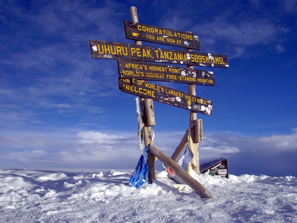
Kibo. Towering 6,985 meters (22,831 feet) above sea level, this iconic peak is one of the world’s most majestic and alluring natural wonders. The central, youngest, and highest cone, home to Uhuru Peak (the very summit) and its distinctive crater. The map will show the routes converging towards Kibo, highlighting the final push to Uhuru Peak. Often via Stella Point or Gilman’s Point on the crater rim.
Static and Dynamic Map of Kilimanjaro
A static map of Kilimanjaro offers a fixed, detailed view of the mountain’s topography, trails, and landmarks. Ideal for offline use and planning. A dynamic map is interactive, allowing users to zoom, pan, and access real-time data like weather, routes, and GPS tracking. Dynamic maps are best for on-the-go navigation, while static maps provide a reliable visual reference. Both serve essential roles in exploring Mount Kilimanjaro effectively and safely. When planning, consider both static and dynamic maps of Kilimanjaro:
Static Maps. These are traditional printed or PDF maps. They offer a fixed, reliable overview. Excellent for pre-trip study, and serve as a crucial backup in the field (no batteries required). They provide a clear visual reference of the entire mountain at once.
Dynamic Maps. These are digital, interactive maps found on GPS devices or smartphone apps. They offer real-time location tracking, zoom capabilities, terrain layering (satellite, topographic), and often 3D views. While excellent for navigation and visualization, they rely on battery life and signal.
Combining both types provides the most comprehensive and secure approach to navigating the “Roof of Africa.” A well-understood Kilimanjaro map transforms a daunting challenge into a clearly defined, achievable journey.

