Mount Kilimanjaro, soaring majestically above the East African plains, is much more than Africa’s highest peak; it is a colossal testament to the Earth’s dynamic geological forces. This iconic mountain, a solitary giant dominating the Tanzanian skyline, is a stratovolcano of immense proportions, shaped over millions of years by fiery eruptions, glacial erosion, and the slow, relentless movement of tectonic plates. Understanding Kilimanjaro’s geology unveils the dramatic story of its birth and evolution, revealing a living, breathing landmark that continues to intrigue scientists and inspire adventurers. Mount Kilimanjaro a dormant stratovolcano (composite volcano) primarily composed of three volcanic cones. Kibo (the highest peak), Mawenzi, and Shira, with Kibo considered potentially active, while Mawenzi and Shira are extinct. Its formation a result of significant volcanic activity linked to the East African Rift, with layers of hardened lava, ash, and other volcanic materials building up over millions of years.
1. Three Volcanic Cones: The Triple Peaks of Power
The term “Three Volcanic Cones: The Triple Peaks of Power” most accurately refers to Mount Kilimanjaro, a massive dormant stratovolcano in Tanzania composed of three distinct volcanic cones: Kibo, Mawenzi, and Shira. Kibo is the highest and dormant, while Mawenzi and Shira are extinct. Kilimanjaro is not a single, monolithic volcano, but rather a complex, interconnected volcanic massif comprised of three distinct cones: Shira, Mawenzi, and Kibo. Each cone represents a different stage in Kilimanjaro’s tumultuous geological history, forming a sprawling volcanic complex. These three cones, while distinct, grew close enough over geological time to merge at their bases, forming the single, massive Mount Kilimanjaro we see today.
Shira (3,962 meters / 13,000 feet). This is the oldest and westernmost of the three cones of Kilimanjaro Geology. Shira a largely eroded, with its western flank having collapsed millions of years ago, forming a broad, relatively flat plateau. Evidence suggests that Shira was once a much taller volcano. Perhaps even rivaling Kibo in height, before its destructive collapse. The extensive caldera has been largely filled by subsequent lava flows from Kibo. Creating the picturesque Shira Plateau that trekkers traverse.
Mawenzi (5,149 meters / 16,893 feet). Located to the east, Mawenzi, the second highest peak of Kilimanjaro and its characterized by its jagged, deeply eroded ridges and pinnacles. It is a much older and more weathered cone than Kibo. Signifying a long period of inactivity and exposure to the elements. Mawenzi considered extinct, its volcanic activity having ceased long ago, leaving behind a dramatic. Craggy landscape that poses a technical climbing challenge in its own right.
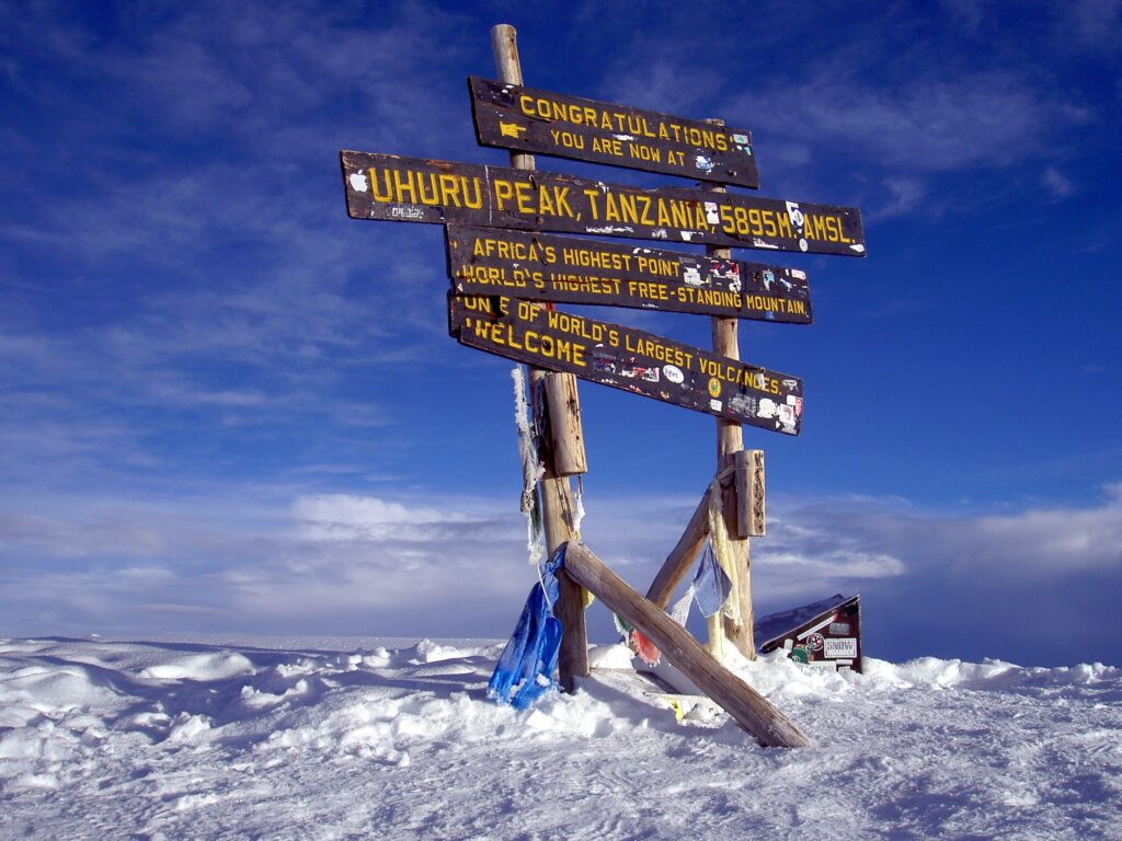
Kibo (5,895 meters / 19,341 feet). The youngest, highest, and most central of the three cones, Kibo home to Uhuru Peak, Africa’s ultimate summit, Kilimanjaro Geology. Kibo a classic stratovolcano with a nearly symmetrical cone shape, culminating in a well-defined crater. Its relatively intact structure indicates more recent activity. Kibo also hosts the famous Ash Pit within its inner crater. A significant feature for geologists studying its past eruptions.
2. Volcanic Origins: Born of Fire and Magma
Kilimanjaro’s very existence, a direct consequence of intense volcanic activity driven by deep Earth processes. Its formation began approximately 2.5 million years ago, with the initial eruptions that built the Shira cone. Subsequent eruptions, spanning millions of years, built up Mawenzi and then Kibo. The magma that fueled these colossal eruptions originated from within the Earth’s mantle. The immense pressure and heat caused molten rock to rise to the surface through fissures and vents, building up layers of solidified lava flows, ash, and volcanic rock, characteristic of stratovolcanoes. Each eruption added to the mountain’s height and girth, progressively shaping its iconic silhouette. The sheer volume of material ejected over geological epochs underscores the immense power of the forces at play.
3. Dormant, Not Extinct: A Sleeping Giant
While Mawenzi considered extinct, Kibo, the summit cone of Kilimanjaro, classified as dormant, not extinct. This distinction is crucial. An extinct volcano has no probability of erupting again, whereas a dormant volcano is merely in a prolonged state of inactivity but retains the potential for future eruptions. The last major eruption of Kibo, estimated to have occurred between 150,000 and 200,000 years ago. However, there is evidence of minor activity much more recently, perhaps as late as 200 years ago. Based on oral traditions and scientific studies of ash deposits.
Within Kibo’s crater, present-day activity confined to fumaroles – vents that continuously release steam, sulfurous gases, and heat. These persistent gas emissions are a clear indication that the magma chamber beneath Kibo is still active, albeit in a very subdued state. While there are no immediate signs of an impending eruption, the classification of “dormant” reminds us that Kilimanjaro’s fiery heart continues to beat.
4. Location Within the East African Rift: A Tectonic Hotspot
Kilimanjaro’s existence and its impressive height intimately linked to its geographical position within the East African Rift System (EARS). The EARS is a divergent plate boundary where the African Plate is slowly splitting into two smaller plates: the Somali Plate to the east and the Nubian Plate to the west. This massive geological process stretches thousands of kilometers from the Red Sea to Mozambique. Characterized by extensive faulting, grabens (rift valleys), and significant volcanism.
Kilimanjaro situated on a branch of the Eastern Rift Valley, and its volcanism is a direct consequence of the thinning of the Earth’s crust in this region. As the crust stretches and pulls apart, it reduces pressure on the underlying mantle. Allowing molten rock (magma) to rise towards the surface, leading to the formation of volcanoes like Kilimanjaro, Mount Meru (its smaller neighbor), and the Ngorongoro Crater complex. Its isolated, free-standing nature, also a characteristic feature of volcanoes associated with rifting. Being part of a fold mountain range formed by colliding plates.
5. Glacial Features: Sculpted by Ice
Despite its proximity to the equator, Mount Kilimanjaro’s immense altitude (over 5,800 meters) allows it to host permanent glaciers and ice fields on its summit. These glacial features are not only stunning but also play a significant role in sculpting the mountain’s upper reaches. During past ice ages, Kilimanjaro’s glaciers were far more extensive, carving out U-shaped valleys, cirques (amphitheater-like hollows), and arêtes (sharp ridges) on its upper slopes. While these larger glacial forms are now mostly relict features, the remaining ice caps on Kibo’s crater rim and outer slopes continue to exert their erosive power, albeit on a reduced scale. The dramatic retreat of these glaciers in recent decades. Widely attributed to climate change, a stark visual testament to the ongoing geological and environmental shifts impacting this iconic mountain.
How was the mountain Kilimanjaro formed? Mount Kilimanjaro’s three peaks were formed after volcanic eruptions millions of years ago guide to the geology of Kilimanjaro. One volcanic cone, Shira, is now extinct and eroded, while the other two, Mawenzi and Kibo, ‘melted’ together after subsequent eruptions. Kibo is now the highest with its famous Uhuru peak at almost 6000m above sea level. Also called a stratovolcano (a term for a very large volcano made of ash, lava and rock), Kilimanjaro, made up of three cones: Kibo, Mawenzi and Shira. Kibo is the summit of the mountain and the tallest of the three volcanic formations.
Mount Kilimanjaro formed in the southern part of the Rift Valley. The giant tectonic plate split into two, and its pieces began to move apart, a process called rifting. The Earth’s crust weakened at the rift, and fiery magma from beneath the Earth’s surface broke through. The most common and visible way mountains, formed is through the convergence of Earth’s tectonic plates. When two lithospheric plates collide, the immense pressure causes the crust to crumple and fold, creating mountain ranges. This process, called orogeny, results in the formation of long, linear mountain belts.
What is the geomorphic process of Mount Kilimanjaro? Kilimanjaro’s volcanic nature, linked to the East African Rift. This geological phenomenon causes the Earth’s crust to split, creating Kilimanjaro. The rifting process resulted in volcanic activity that shaped the mountain. Tectonic plate movements, primarily the African and Somali plates, exert immense pressure on Kilimanjaro’s subsurface. This creates conditions favourable to volcanic activity.
Mount Kilimanjaro is a dormant, three-coned stratovolcano whose last major eruptive phase occurred approximately 360,000 to 200,000 years ago, although minor phreatic (steam-driven) events and the venting of sulfurous gases from near the summit indicate ongoing geological activity. The three volcanic cones that formed the mountain are Shira, Mawenzi, and Kibo, with Kibo being the youngest and currently the highest peak. While scientists monitor Kilimanjaro and see no signs of an imminent eruption, future activity is possible in the very distant future.
In conclusion,
Mount Kilimanjaro is a living geological museum. Its three distinct cones, born from ancient volcanic forces, its classification as a dormant giant nestled within the Earth’s Great Rift, and the evidence of both ancient and rapidly disappearing modern glaciers all combine to tell a powerful story of dynamic planetary processes. This geological narrative not only defines its physical form but also underpins its immense cultural significance and its enduring allure for those who venture to stand atop its fiery heart.


