How Mount Kilimanjaro Was Formed: Volcanoes, Rifts and Glaciers
How Was Mount Kilimanjaro Formed?
Rising majestically above the plains of northern Tanzania, Mount Kilimanjaro, Africa’s highest peak is not just a trekking icon but a powerful geological story written over millions of years. Understanding how Mount Kilimanjaro was formed reveals a fascinating blend of volcanic activity, tectonic movement, and climatic transformation. This UNESCO World Heritage Site stands as a dormant stratovolcano composed of layered lava, ash, and rock shaped by the forces of the Earth’s crust. From its towering snow-capped summit to its lush lower slopes, Kilimanjaro showcases diverse landscapes influenced by its dramatic origins. Today, it is one of the world’s most popular mountain-climbing destinations. Exploring its formation provides insight into the dynamic processes that continue to shape our planet and define iconic natural landmarks worldwide.
Kilimanjaro formation timeline (approximate)
- 1Rifting: the East African Rift thins the crust and magma rises.
- 2~2.5 million years ago: Shira, the oldest cone, begins erupting.
- 3~1 million years ago: Mawenzi builds up to the east.
- 4~460,000 years ago: Kibo, the central cone, begins its main growth.
- 5~360,000 years ago: the last major eruption.
- 6~200,000 years ago: the last minor volcanic activity.
- 7~11,700 years ago: the oldest ice in today’s summit glaciers forms.
What Caused the Formation of Mount Kilimanjaro?
Mount Kilimanjaro, Africa’s highest mountain, was formed by powerful volcanic forces linked to the East African Rift System. Millions of years ago, tectonic plate movement caused the Earth’s crust to split, allowing molten magma to rise and create a massive stratovolcano. This geological activity built Kilimanjaro’s iconic peaks—Kibo, Mawenzi, and Shira. Today, its dramatic formation attracts hikers, geologists, and travelers from around the world.
The Role of the Great Rift Valley
The formation of Mount Kilimanjaro is deeply connected to the East African Rift system, part of the vast Great Rift Valley. This immense geological feature stretches thousands of kilometers across Africa and is formed by tectonic plates slowly pulling apart. As the Earth’s crust thins, magma rises from beneath the surface, creating ideal conditions for volcanic activity. Kilimanjaro emerged near the eastern branch of this rift, where intense pressure and heat allowed molten rock to break through. This process, known as continental rifting, continues today, making the region geologically active. The Rift Valley’s influence explains why East Africa hosts many volcanoes and dramatic landscapes. Kilimanjaro’s existence is therefore a direct result of these deep-seated tectonic forces shaping the African continent over millions of years.
- Plates pull apartNubian & Somali
- Crust thinsRift forms
- Magma risesThrough weak crust
- Volcano buildsKilimanjaro
Volcanic Origins of Kilimanjaro
Mount Kilimanjaro is a classic example of a stratovolcano, formed through repeated volcanic eruptions over time. These eruptions released layers of lava, ash, and volcanic debris that gradually built the mountain’s immense structure. Unlike explosive volcanoes, Kilimanjaro’s eruptions were mostly effusive, meaning lava flowed steadily rather than violently exploding. This allowed the mountain to grow tall and broad. Geological studies suggest that Kilimanjaro began forming around 2.5 million years ago, making it relatively young in geological terms. The volcano’s formation involved multiple phases of activity, each contributing to its current shape. Over time, cooling lava hardened into rock, creating the stable base we see today. These volcanic processes are responsible for Kilimanjaro’s towering presence, making it the highest freestanding mountain in the world.
Formation of the Three Cones
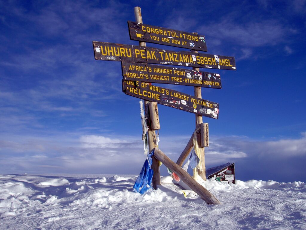
One of the most distinctive features of Mount Kilimanjaro is its three volcanic cones: Kibo, Mawenzi, and Shira. Each cone represents a different stage in the mountain’s geological evolution. Shira is the oldest and has largely eroded into a plateau, while Mawenzi is rugged and heavily weathered, indicating it is no longer active. Kibo, the tallest cone, remains dormant and hosts the famous Uhuru Peak. These cones formed from separate volcanic vents, each erupting at different times. Over thousands of years, lava flows and eruptions built these structures layer by layer. The variation in their shapes and conditions provides valuable clues about Kilimanjaro’s volcanic history. Together, they create a unique triple-peaked formation rarely seen elsewhere, making Kilimanjaro a geological wonder and a major attraction for climbers and researchers alike.
Lava Flows and Mountain Growth
The growth of Mount Kilimanjaro was driven by continuous lava flows that spread outward and solidified over time. These flows created the broad base of the mountain, allowing it to rise gradually rather than forming steep, jagged peaks. As molten rock cooled, it formed layers of basalt and other volcanic materials, adding height and stability. Repeated eruptions over thousands of years built the mountain into a massive stratovolcano. Some lava flows extended for kilometers, shaping the surrounding plains and contributing to fertile soils in the region. This fertility supports agriculture and diverse ecosystems today. The steady accumulation of lava layers explains Kilimanjaro’s smooth slopes compared to more explosive volcanic mountains. These geological processes highlight the slow but powerful forces that can create some of Earth’s most iconic natural landmarks.
- Lava flows
- Ash layers
- Basalt
- Phonolite
- Trachyte
- Fertile volcanic soils
Dormant but Not Extinct
Although Mount Kilimanjaro is currently dormant, it is not considered extinct. Geological evidence suggests that its last major eruption occurred approximately 360,000 years ago, with minor volcanic activity possibly continuing later. The presence of fumaroles—vents releasing gas—near Kibo’s crater indicates that heat still exists beneath the surface. Scientists classify Kilimanjaro as a dormant volcano, meaning it could potentially erupt again in the distant future. However, there are no immediate signs of impending activity, making it safe for tourism and climbing. This dormant status adds to Kilimanjaro’s intrigue, as it remains a living geological structure rather than a completely inactive one. Its volcanic past continues to shape its landscape, and ongoing monitoring helps scientists understand potential risks and the long-term evolution of this iconic African mountain.
Erupting now or recently, with clear signs of ongoing activity.
Not erupting, but heat remains below. Kibo’s fumaroles still release gas, so it could erupt again in the distant future.
Not expected to erupt ever again; its magma supply is gone.
Glaciers and Ice Cap Formation
Despite its location near the equator, Mount Kilimanjaro is famous for its glaciers and ice cap. These formed during colder climatic periods when temperatures allowed snow and ice to accumulate at high altitudes. Over time, this snow compressed into glaciers, creating the iconic white summit seen in photographs. The altitude of Kilimanjaro, reaching 5,895 meters, plays a crucial role in maintaining these icy conditions. However, climate change has significantly reduced the size of these glaciers, making them a key focus of environmental studies. The ice cap also influences local weather patterns and water sources, contributing to ecosystems on the mountain’s slopes. Kilimanjaro’s glaciers are not just visually striking but also scientifically important, offering insights into historical climate conditions and the ongoing impact of global warming.
Erosion and Landscape Shaping
Erosion has played a major role in shaping the present-day appearance of Mount Kilimanjaro. Wind, rain, and temperature changes gradually wear down volcanic rock, carving valleys, ridges, and slopes. Over thousands of years, these processes have softened the mountain’s features, especially on older cones like Shira and Mawenzi. Glacial activity also contributed to erosion, particularly during colder periods when ice carved out sections of the mountain. This combination of erosion and volcanic formation has created a diverse landscape with varying terrain. The lower slopes are gentle and fertile, while higher elevations become rocky and barren. These changes influence vegetation zones and wildlife habitats. Erosion continues to shape Kilimanjaro today, ensuring that its landscape remains dynamic and ever-evolving, reflecting the balance between constructive and destructive geological forces.
Influence of Tectonic Activity
Tectonic activity remains a fundamental factor in the formation and evolution of Mount Kilimanjaro. The movement of the Nubian (African) and Somali plates within the East African Rift continues to create stress beneath the Earth’s crust. This movement allows magma to rise, fueling volcanic systems like Kilimanjaro. Although the mountain itself is currently dormant, the surrounding region remains geologically active. Earthquakes and ground shifts occasionally occur, indicating ongoing tectonic processes. These forces not only contributed to Kilimanjaro’s initial formation but also influenced its long-term stability. The interplay between tectonics and volcanism is essential in understanding why Kilimanjaro exists and how it may change in the future. This dynamic geological environment highlights the powerful natural forces shaping East Africa and reinforces Kilimanjaro’s significance as a living geological landmark.
Kilimanjaro’s Geological Significance
Mount Kilimanjaro holds immense geological significance as one of the largest freestanding volcanic mountains in the world. Its structure provides valuable insights into stratovolcano formation, tectonic activity, and volcanic evolution. Scientists study Kilimanjaro to better understand how continental rifting leads to volcanic activity. Its three distinct cones offer a rare opportunity to examine different stages of volcanic development in one location. Additionally, the mountain’s preserved lava layers and geological formations serve as a natural archive of Earth’s history. Kilimanjaro’s prominence also makes it a key reference point in African geography and geology. Beyond its scientific importance, it symbolizes the powerful natural processes that shape our planet. This combination of research value and visual grandeur makes Kilimanjaro one of the most studied and admired mountains globally.
- Kilimanjaro is a stratovolcano.
- Shira is the youngest of the three cones.
- Kilimanjaro is an extinct volcano.
- Kilimanjaro is the highest freestanding mountain in the world.
- Kibo still has fumaroles that release volcanic gas.
Ecosystems Shaped by Formation
The formation of Mount Kilimanjaro has directly influenced its unique ecosystems. As the mountain rose, it created distinct climate zones based on altitude, ranging from tropical forests at the base to alpine deserts and icy summits. Volcanic soils, enriched by minerals from lava, support lush vegetation and diverse wildlife. These fertile conditions make Kilimanjaro’s lower slopes ideal for agriculture, particularly coffee farming. Each ecological zone hosts different plant and animal species, contributing to the mountain’s biodiversity. The gradual slope formed by lava flows allows these ecosystems to transition smoothly from one zone to another. This diversity attracts researchers, conservationists, and tourists alike. Kilimanjaro’s ecosystems are a direct result of its geological origins, demonstrating how volcanic activity can shape not only landscapes but also thriving natural environments.
Cultural and Historical Importance
Beyond its geological story, Mount Kilimanjaro holds deep cultural and historical significance. For local communities such as the Chagga people, the mountain is a symbol of life, providing water, fertile land, and spiritual meaning. Historically, Kilimanjaro has fascinated explorers, with early expeditions in the 19th century capturing global attention. It became a symbol of adventure and discovery, eventually gaining recognition as a UNESCO World Heritage Site. The mountain also plays a role in African identity and tourism branding, often representing the natural beauty of the continent. Its formation has influenced human settlement, agriculture, and cultural traditions in the region. Today, Kilimanjaro continues to inspire climbers and travelers worldwide, blending natural history with human heritage in a way few landmarks can match.
Modern Exploration and Tourism
Today, Mount Kilimanjaro is one of the world’s most popular trekking destinations, attracting thousands of climbers each year. Its geological formation contributes to its appeal, offering diverse landscapes and scenic routes such as Machame, Marangu, and Lemosho. Tourism plays a vital role in Tanzania’s economy, with Kilimanjaro among its best-known attractions. Modern exploration combines adventure with scientific research, as climbers often learn about the mountain’s volcanic origins and ecological zones. Sustainable tourism efforts aim to preserve Kilimanjaro’s environment while supporting local communities. Advances in safety, guiding services, and infrastructure have made climbing more accessible. This blend of natural wonder, geological history, and adventure tourism ensures Kilimanjaro remains a bucket-list destination for travelers seeking both challenge and discovery.
- Machame
- Marangu
- Lemosho
- Rongai
- Northern Circuit
- Umbwe
Geology of Mount Kilimanjaro
The geology of Mount Kilimanjaro reveals a complex volcanic structure formed by three cones: Kibo, Mawenzi, and Shira. Kibo, the highest and central cone, dominates Kilimanjaro trekking routes and summit attempts to Uhuru Peak. Mawenzi is rugged and eroded, while Shira is the oldest and a collapsed cone. Layers of lava, ash, and volcanic rock define its terrain. Its glaciers and alpine desert zones enhance its global appeal, drawing climbers, researchers, and travelers interested in Africa’s natural wonders and high-altitude ecosystems.
Dormant Status, Last Eruption and the Name Kilimanjaro
Mount Kilimanjaro is classified as a dormant volcano, not currently active but not extinct. Kibo, its central cone, still shows signs of volcanic activity, including fumaroles that release gas from beneath the Earth’s surface. Although there is no immediate eruption threat, scientists continue to monitor it. Its dormant status makes it a safe yet thrilling climb.
Mount Kilimanjaro last experienced major volcanic activity approximately 360,000 years ago, with its most recent minor eruptions occurring around 200,000 years ago. These eruptions shaped Kibo’s summit crater and contributed to the mountain’s present structure. Since then, Kilimanjaro has remained dormant, making it safe for trekking and tourism. Today, it stands as a UNESCO-recognized natural wonder and a highlight of Tanzania safari and trekking itineraries.
The meaning of “Kilimanjaro” is still debated, but it is widely believed to originate from the Swahili and Chagga languages spoken in Tanzania. “Kilima” may mean “mountain” or “hill” in Swahili, while “Njaro” could refer to “whiteness” or “shining,” possibly describing its snow-capped peak. Some interpretations suggest “Mountain of Greatness” or “Mountain of Caravans.” As Africa’s tallest peak, Kilimanjaro holds cultural, historical, and tourism significance and is one of the world’s most iconic trekking destinations.
Final Thought
The story of Mount Kilimanjaro is a powerful reminder of the Earth’s dynamic nature. Formed through volcanic eruptions, shaped by tectonic forces, and refined by erosion and climate, Kilimanjaro stands as a testament to millions of years of geological evolution. Its towering presence, diverse ecosystems, and cultural importance make it far more than just a mountain—it is a living symbol of natural history and human connection. As interest in African safaris, adventure travel, and sustainable tourism continues to grow, Kilimanjaro remains at the forefront of global exploration. Understanding how it was formed enriches the experience of visiting or climbing it, turning every step into a journey through time. Kilimanjaro is not just climbed—it is studied, admired, and deeply respected worldwide.
Kilimanjaro Formation: FAQs
How was Mount Kilimanjaro formed?
Mount Kilimanjaro was formed by volcanic activity linked to the East African Rift. As tectonic plates pulled apart, the crust thinned and magma rose to the surface. Repeated eruptions of lava, ash and rock built a huge stratovolcano with three cones, Shira, Mawenzi and Kibo, while erosion and glaciers shaped its present form.
Is Mount Kilimanjaro an active volcano?
No. Mount Kilimanjaro is a dormant volcano, not active and not extinct. Its central cone, Kibo, still has fumaroles that release gas, showing heat remains below the surface. There are no signs of an imminent eruption, and scientists continue to monitor the mountain.
When did Mount Kilimanjaro last erupt?
Kilimanjaro’s last major volcanic activity occurred roughly 360,000 years ago, with minor activity around 200,000 years ago. These eruptions shaped Kibo’s summit crater. Since then, the mountain has remained dormant, making it safe for trekking.
What are the three volcanic cones of Kilimanjaro?
Kilimanjaro has three cones. Kibo, the tallest and youngest, is dormant and holds Uhuru Peak at 5,895 metres. Mawenzi, at 5,149 metres, is rugged and heavily eroded. Shira, the oldest, has collapsed and eroded into a high plateau.
How old is Mount Kilimanjaro?
Kilimanjaro began forming roughly 2.5 million years ago when the Shira cone first erupted. Mawenzi followed, and Kibo, the youngest cone, grew mainly over the last half a million years. In geological terms, this makes Kilimanjaro a relatively young mountain.
Are Kilimanjaro’s glaciers disappearing?
Yes. Kilimanjaro’s glaciers have lost more than 80 percent of their ice since the early 20th century, and scientists expect much of the remaining ice could disappear in the coming decades. The oldest summit ice is about 11,700 years old, making the glaciers a valuable record of past climate.
What does the name Kilimanjaro mean?
The meaning is debated. “Kilima” may mean “mountain” or “hill” in Swahili, while “Njaro” could mean “whiteness” or “shining”, possibly describing the snow-capped summit. Other interpretations include “Mountain of Greatness” and “Mountain of Caravans”.
Is it safe to climb Kilimanjaro if it is a volcano?
Yes. Kilimanjaro is dormant, and there are no signs of impending volcanic activity. The main challenges are altitude and cold, not eruptions. Choosing a longer route, climbing slowly with experienced guides and acclimatizing well give you the best chance of a safe, successful summit.
Climb Kilimanjaro With Confidence
Walk through millions of years of volcanic history. Tell us your dates and fitness, and our mountain team will plan a safe, well-acclimatized private climb.